Getting to Lofoten Islands
The main problem is the remoteness of the islands. For example, the distance from the Oslo by car is 1800 kilometers. With a ferry the distance can be reduced to 1400 kilometers, but in any case you need at least 2 full days of travelling one way. It is impossible to get to the islands by bus or train from Oslo. You can get to Bodø and Narvik and then find a transfer to local buses / ferries. Actually, the whole northern Norway is designed exclusively for autotravelers.
The vast majority of tourists come on the Bodø - Moskenes ferry. There are quite a lot of ferries in summer, but still it is better to buy tickets at least one day in advance. During boarding select the line for those who bought online tickets.

Map of Lofoten Islands ©@
The second option is by car by land. This option appeared only in 2007 when new road was built. From the south it is better to go through the territory of Sweden, since the roads are much faster. You will drive through the Abisko national park (Sweden) and Bjerkvik (Norway).
The easiest way is to fly by plane from Oslo or Bodø. Airports Leknes (LKN) and Svolvær (SVJ) are located on the islands. Airports Bodø (BOO) and Narvik (EVE) are located close to the islands. On-site is better to rent a car, since airports of Leknes and Svolvær are so small that even have no buses, only taxis.
We were driving our car from the south of Norway using the Bodø - Moskenes ferry. Then crossed all the islands to the north and went to Sweden.
Public transport
If you miraculously hit Lofoten without a car, then use these service to search for buses: https://en-tur.no/. The longest route on the islands is from the village Ä to the capital Svolvær, ticket price 210 NOK (21 EUR). Just start from the south, visit interesting places and catch the next bus.
Arctic Circle
The islands are located beyond the Arctic Circle, which means there are days when the sun does not hide behind the horizon during the night. Located at 68 degrees north latitude. The same latitude as northern Alaska, northern Siberia and Greenland.
Weather
Thanks to the Gulf Stream it is relatively warm here. But the climate is still awful. Even with the forecast for the next days, it's impossible to plan anything. If you get a few days of good weather, then you are incredibly lucky. We could not complete even half of our plans due to fog. Check the weather on this website.
Our hotels on the Lofoten Islands
So, we arrived by ferry to Moskenes. It was night however we still saw the sun.

Lofoten Islands ©Yuriy Buriak
Before going to the hotel we went to the viewpoint in Reine (N 67 55.706 E 13 05.057), which is located a few kilometers away from Moskenes. This is the most famous lookout on the islands and their visiting card.

Lofoten Islands ©Yuriy Buriak
Don't forget, it's 2 AM!. But at this time there is no wind and you can get a perfect water "mirror".

Lofoten Islands ©Yuriy Buriak
If you arrive late in the evening, there are few options for accommodation: either a tent or Lofoten Planet Basecamp (booking.com). This is something like a hostel, it is automatic, so you can enter wuth a code at any time. Double rooms and a good shared kitchen. Park the car according to your room number. On the booking.com this is one of the cheapest options, of course if prices from 100 EUR are "cheap" for you. We could have stayed there for more days, but the location in the very south of the islands did not suit us.
The next place to stay - Lydersen Rorbuer (booking.com). There are different rooms, we took the apartment. Rorbu (plural rorbuer) is a traditional Norwegian word, meaning a wooden house where fishermen live during the season. Now they are converted into tourist hotels.
This place is located on the outskirts, but if you have a car, we highly recommend it. The view is one of the best hotel views that we saw.

Lofoten Islands ©Yuriy Buriak
Photo from the drone, but the views from the ground are excellent as well.

Lofoten Islands ©Yuriy Buriak
Last night we spent in the village of Henningsvær in Johs. H. Giæver Apartments (booking.com).
In all three places we had a kitchen. Food can be purchased in Bodø where are many supermarkets, we were in this one N 67 16.944 E 14 24.829. Apartments are more expensive than an ordinary hotel, about 120 - 140 EUR. But keep in mind that restaurants on the islands are very expensive and your bill can easily be over 100 EUR. Check here the menu of a traditional local restaurant. Our 3-day food from the supermarket cost 60 EUR.
Since there are not many hotels on the Lofoten we had a tent. But as it turned out you can find accommodation without problems even 1-2 days before the arrival.
What to do on the Lofoten islands
Now we describe what you can do on the islands. We visited only a small part of these places. The main website where you can find information about tourist routes on the islands - http://www.68north.com. All the places (except the first one) are located from south to north.
Værøy
Separate island in southern Lofoten. It is located far south of Moskenes and not visited by mass tourists. You can get there by ferry Bodø - Værøy or Moskenes - Værøy. Or fly a helicopter from Bodø (http://lufttransport.no/). Very beautiful place, the lookout is located here N 67 39.803 E 12 37.602.

Værøy ©@
Reinebringen
Near the village of Reine there is not only a beautiful lookout near the water, but also the best lookout on Lofoten (parking is the same N 67 55.706 E 13 05.057). Check here information about the trail and photos. We really wanted to get on the top of the mountain, but the weather did not allow. The path is difficult but after the lookout has become popular on Instagram, officials are trying to improve the path with the boulders. As of December 2025 the work is already finished.
The fishing village of Reine is considered the most picturesque on the islands.
Viewpoint on the Hamnoy bridge
You can park nearby N 67 56.709 E 13 08.066.

Lofoten Islands ©Yuriy Buriak
Kvalvika Beach
Beautiful beach surrounded by mountains. There are two options to visit it. You can park here N 68 04.108 E 13 07.786 and take the trail to the beach. The distance is 2 km, climb is only 170 meters.
The second option is difficult, but much more interesting. Park here N 68 05.465 E 13 08.944 and go to the top of the Ruten mountain. Information about the trail and photos can be found here. You will need the maps.me app not to get lost.
Rambergstranda
The huge beach is located on the main road and visited by absolutely all tourists. Parking here N 68 05.908 E 13 14.722.

Lofoten Islands ©Yuriy Buriak
Nusfjord
One of the oldest and well-preserved fishing villages. Pretty small, you can get around in 20 minutes. Parking N 68 02.139 E 13 20.777.
Stornappstinden
Mountain with beautiful views (google street view), find here information about the trail and photos. Parking N 68 07.777 E 13 23.400.
Holandsmelen
Mountain with beautiful views, find here information about the trail and photos. Parking N 68 10.564 E 13 31.472.
Mannen
Mountain with beautiful views of the beach Haukland. Find here information about the trail and photos. Parking N 68 11.976 E 13 31.951.
Lofotr Viking Museum (https://www.lofotr.no/en/)
A complete reconstruction of the 83-meter house (the longest ever found in Norway), a forge, two ships. Parking N 68 14.689 E 13 45.394.
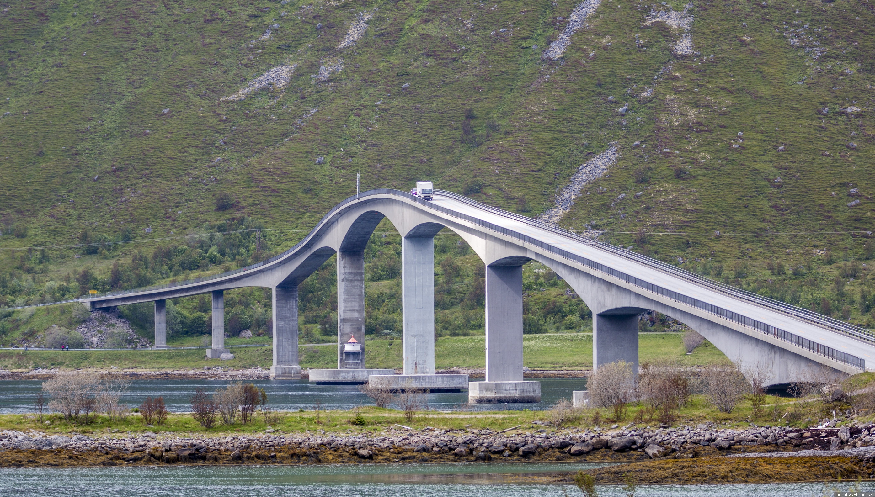
Gimsøystraumen tidal
Picnic place with a toilet and a good view of the bridge. Parking N 68 15.631 E 14 16.183.
Lofoten Islands ©Yuriy Buriak
Henningsvær
We spent the night here, but the fishing village is a must anyway as it is incredibly beautiful.

Lofoten Islands ©Yuriy Buriak

Lofoten Islands ©Yuriy Buriak
Here located the famous football stadium. Like many other attractions, it became famous with the spreading of the drone photography. Pepsi offered support for the 2018 Champions League final here, but UEFA gave the rights to Kyiv.

Lofoten Islands ©Yuriy Buriak
We recommend to climb the nearest mountain. Parking is here N 68 10.202 E 14 13.257 then go forward a bit and start to climb, approximately here N 68 10.293 E 14 13.255.
You have two options: turn right and go to the viewpoint which we visited.
Lofoten Islands ©Yuriy Buriak
Or turn left and go to the top of the Festvågtind mountain (541 m, info). We didn’t see much sense in the further rise, since the view from our current location was stunning.
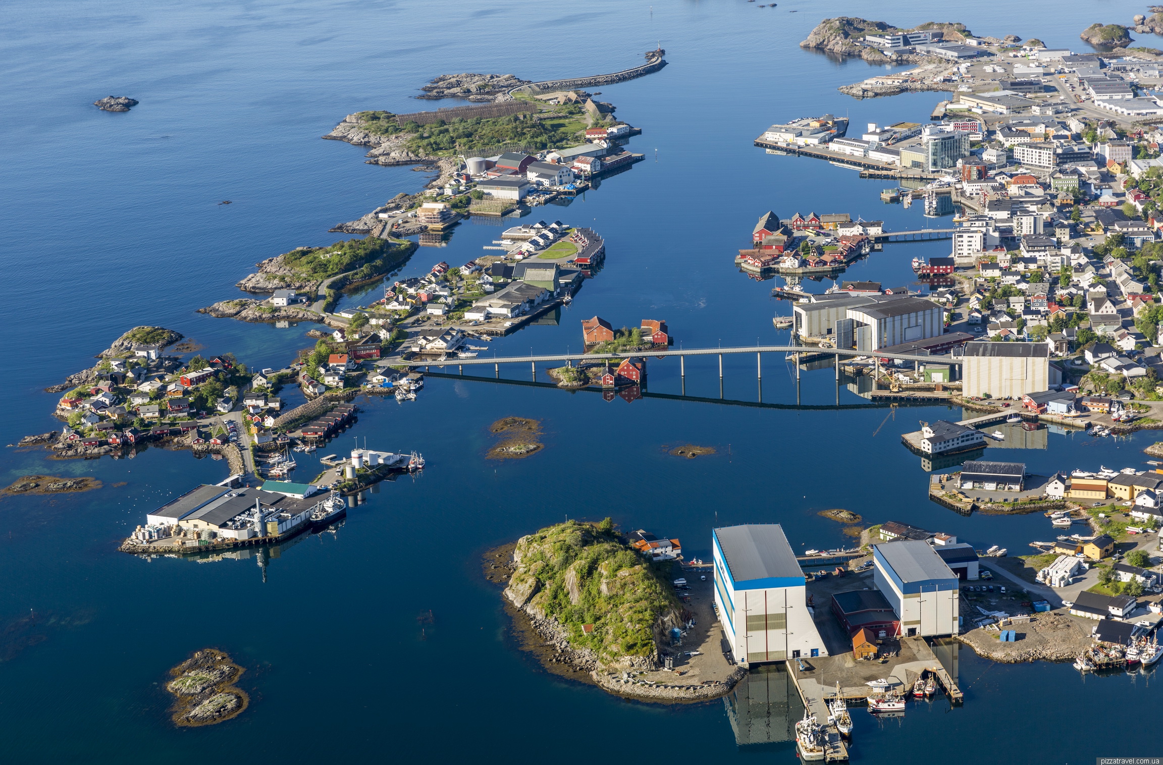
Kabelvåg
Fishing village. We parked here N 68 12.402 E 14 29.107 and walked along the pier to the lighthouse, a very picturesque place. In the same village stands the largest wooden church in Norway. It is located near the road, you will not miss it.

Lofoten Islands ©Yuriy Buriak
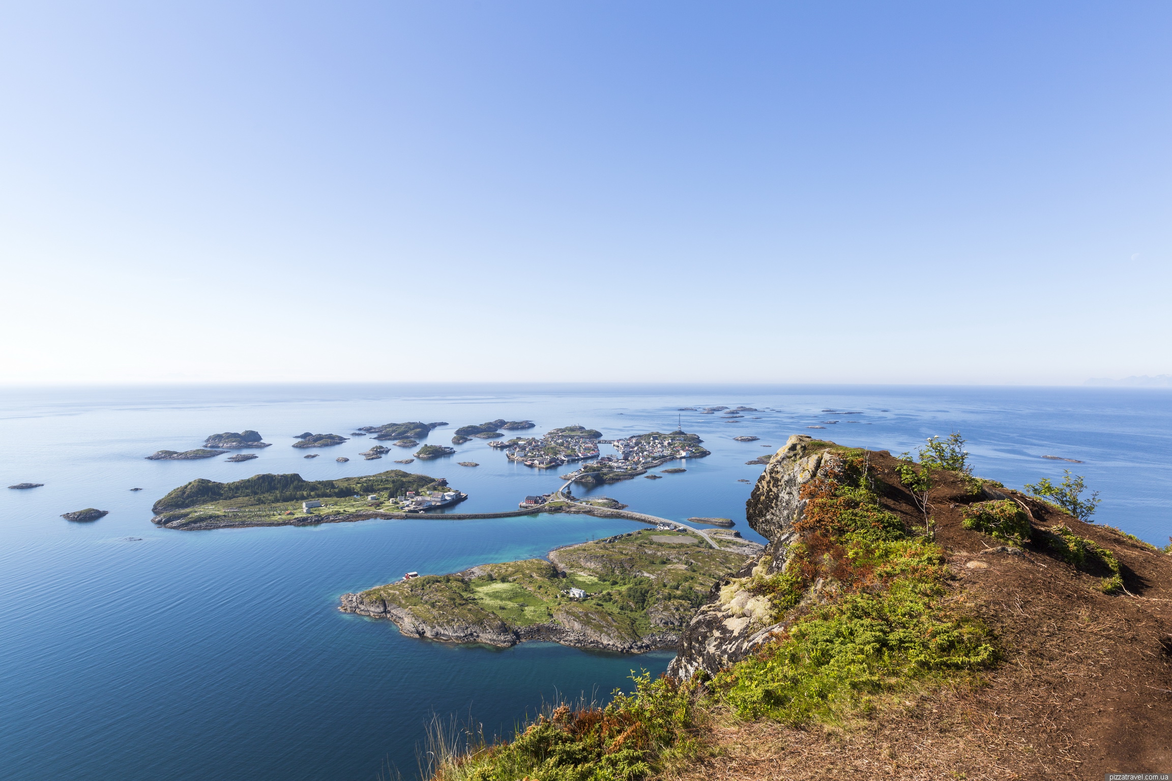
Svolvær
The largest city in Lofoten. We did not walk in the city itself, but we climbed the mountain above it. Parked here N 68 14.663 E 14 34.678, near the start of the trail.
The trail leads to the Fløya mountain, climb is about 600 meters. Track can be viewed here. We did not plan to climb so high and climbed to the interesting rock Svolværgeita, it is somewhere halfway, to the right.

Lofoten Islands ©Yuriy Buriak
Lofoten Islands ©Yuriy Buriak
The Svolværgeita rock is a popular place for climbers. If you want to climb you are not a budget traveler, check this website https://www.alpineguides.no/services/climb-svolvaergeita/.

Lofoten Islands ©Yuriy Buriak

Lofoten Islands ©Yuriy Buriak
Trollfjorden
Very narrow and picturesque fjord. Can be reached only by water, for example, on a ship from Svolvær (pier near Thon Hotel). There are many companies, you can check information here https://www.trollfjordcruise.com/ or here https://www.xxlofoten.no/trollfjord-cruise/.
Austnesfjorden
Picnic place and lookout. Parking N 68 18.957 E 14 42.948.

Lofoten Islands ©Yuriy Buriak
Of course this is not all beautiful places, only the most interesting. During your trip, you will constantly stop and take pictures of every corner.
Whale watching
A popular activity, though we will never take it in Norway. In order to look at the whale's back for a couple of seconds, you will spend a lot of money and time.
From conversations with local people we learned that in the spring whales can be seen on the west coast of the islands just from the land.
Northern Lights
Lofoten Islands are considered a good place to observe this natural phenomenon. If you want to see it, use a special website with forecast http://www.norway-lights.com/#the-lofoten-islands. But before go to Google and read why it is so beautiful in the pictures, but in reality you will see a black sky with a slight glow. Just not to be disappointed.


